Grampians 4WD Tracks
Australia has some world class 4WD tracks, and we’re always keen to find, do, and write about them. When we first saw the Grampians in the distance, I knew there had to be some amazing 4WD tracks to explore, but if I’m completely honest had a hard time trying to find where.
After a fair big of digging around I did find where a lot of them are, and we managed to do almost every single one that was open when we visited. Unfortunately for us though, with a fairly hectic 2022 a lot of the tracks were damaged, and that meant they were off limits.


Where are the Grampians?
You’ll find this stunning part of Victoria directly north of Portland, around the Halls Gap and Hamilton region. You can see them from a mile away, and its a sight to behold, regardless of what direction you are heading in.
What are the 4WD tracks like?
The Grampians 4WD tracks range from basic sand and gravel ones, through to nasty hill climbs, with plenty of rocks, ruts and everything else in between. We didn’t do anything overly extreme in the Grampians as it was still closed, but I’ve heard that some of the Grampians 4WD tracks require the right vehicle and driver!

Finding road closures for Grampians 4WD tracks
If you are planning on heading to the Grampians to do some 4WD tracks, you should consult the Parks Victoria website for up to date road closures, and if its been a while since it was updated, give them a call. We did this to clarify conditions, and when put through to their Halls Gap office found them really helpful.
At the bottom of this page, there’s a link that takes you to the most up to date road closures, and you’ll get a good understanding of what is actually open and closed here. There is an interactive map which we found pretty useless, and this means you still need to find the road that is closed on the map, and work out where (and how) you are going to drive.
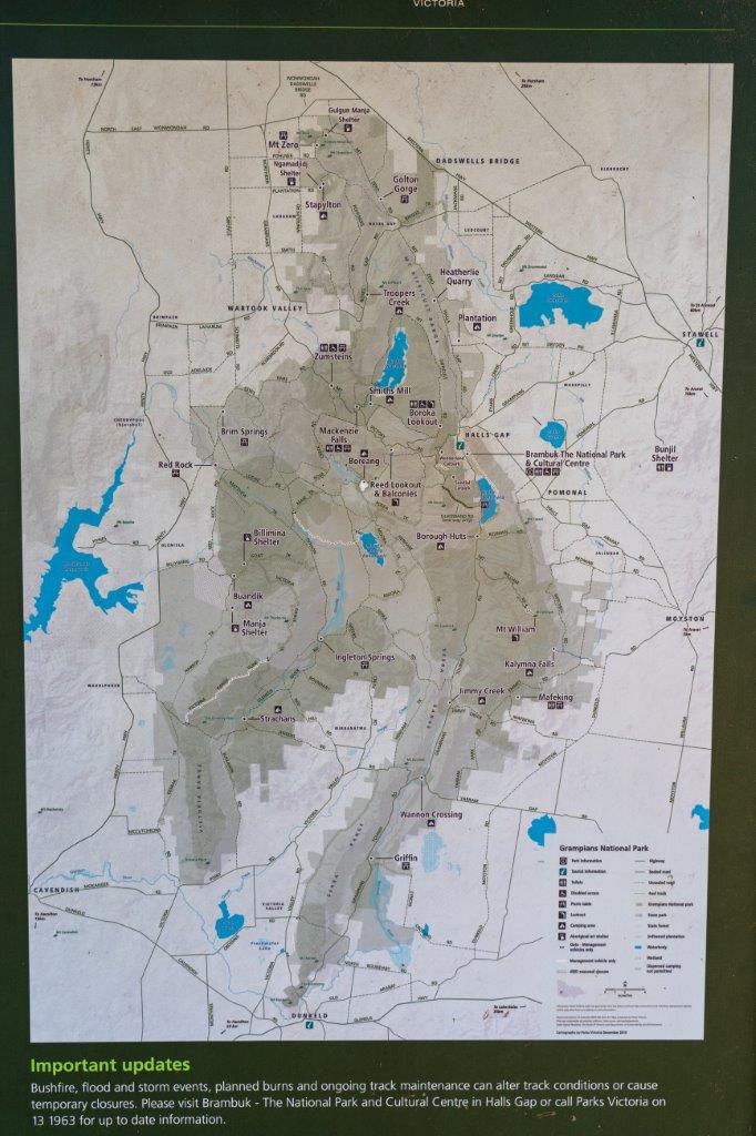
Grampians 4WD Track Maps
Once you know what is open and closed, you’ll need to map out how you are going to tackle the Grampians National Park. I took a photo of a good map at Boreang Campground, which showed many, and you can see some on the Grampians Visitor Brochure from Victoria Parks.
Alternatively, any decent mapping software (like Exploroz Traveller, or even Newtracs) will show you the road names. Admittedly this took a while to find each road and make a pathway, but it does work. There are local maps that you can purchase which cover them better, but any good mapping software should be adequate, with Newtracs making it the easiest to find different tracks.
What 4WD tracks did we do?
Mount Difficult 4WD Track
This is a fun, short 4WD track near Plantation Campground that we thought was worth doing. The views are good, there’s a couple of semi technical bits and it was a bit of fun.

Phillip Island 4WD Track
Phillip Island 4WD track starts at Boreang Campground, and is an easy sand and gravel track that takes you out to Syphon Road, where a lot more Grampians 4WD Tracks start.

Goat Track
Our favourite 4WD track in the Grampians was Goat Track, which starts on Syphon Road and goes up the range, before coming down the other side near Buandik Campground. This is relatively easy, but its steep, has amazing views and a couple of semi technical bits. It’s reasonably short, and well and truly worth doing.

Harrop Track
I’m not sure why this is classified as a 4WD Track, as it was nothing more than a gravel road when we did it, with a couple of holes as you enter and exit the various bridges. Its got nice scenery, but we’d not go out of our way to do it again.

What other 4WD tracks are there?
Beehive Track
Black Range Road
Boundary Road
Outlet Track
Cassidy Gap Road
Coppermine Track
Golton South Track
Heatherlie Track
Henham Track
Henham Track South
Hines Track
Oslers Track
Taylors Track (Burrong shortcut)
Wallaby Rocks Road
Yanganaginj Nwaji Track
Bellfield Fireline
Billywing Track
Briggs Track
Burnt Hut Track
Chinaman Track
Fields Track
Flagstaff Track
Geerack Track
Homestead Track
Launders Track
Link Track
Lynches Crossing Track
Mair Track
Matthews Track
Moora Track
Mt Cassel Fireline
Muirfoot Track
Rosea Track
Saunders Track
Victoria Range Track
When’s the best time to do the Grampians 4WD Tracks?
This is going to entirely depend on the season you get, and how things fare. When we visited a huge number of tracks were still unopened due to crazy rainfall much earlier on. Spring would be a magic time to visit if the tracks are open, but likely going into Summer and Autumn is going to be more suitable for getting access to all of the tracks.
Either way, its a ripper place to explore by 4WD. Have you done any of the Grampians 4WD Tracks?


